


VRTool
คำอธิบายของVRTool
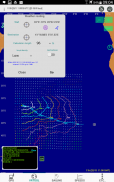
VRTool "SideKick" (VSK) integrates charting, sailing calculator and GPS data logger. It transforms your GPS enabled phone or tablet in a powerful sail boat racing tool.
Now it brings most of VRTool desktop charting features, packed in this mobile app. Key data components used by VSK in charts and calculations include:
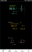
- GPS position ( or you can type coordinates )
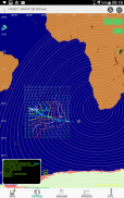
- GSHHS world maps
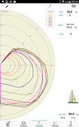
- Polar chart for your boat ( customized ).
- NOAA GFS wind forecasts.
VSK shows the current polar line, TWA, sail efficiency, best course to destination, great circle distance and course. Also operates as a data logger, saving boat positions and other sailing variables periodically.
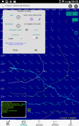
Charting tools include: measure tool, route and track design, add mark, add geodesic circles. Weather routing calculation up to 144h, with hi-res collision detection.
Real time editor for your customized boat polars. Edit polars as you sail by dragging the curve points.
Sidekick can also be configured to act as a NMEA talker, broadcasting GPS messages to other software connected to the boat TCP/IP network via boat wi-fi.
VRTool "เพื่อนสนิท" (VSK) บูรณาการการสร้างแผนภูมิ, เครื่องคิดเลขการแล่นเรือใบและ GPS Data Logger มันแปลงโทรศัพท์ที่ใช้ระบบ GPS หรือแท็บเล็ตของคุณในการแล่นเรือเครื่องมือที่มีประสิทธิภาพการแข่งเรือ
ตอนนี้ก็นำส่วนใหญ่ของ VRTool คุณสมบัติสก์ท็อปสร้างแผนภูมิบรรจุใน app มือถือนี้ ส่วนประกอบที่สำคัญข้อมูลที่ใช้โดย VSK ในชาร์ตและการคำนวณรวมถึง:
- ตำแหน่งจีพีเอส (หรือคุณสามารถพิมพ์พิกัด)
- GSHHS แผนที่โลก
- แผนภูมิขั้วโลกสำหรับเรือของคุณ (เอง)
- การคาดการณ์ NOAA ระบบสศคลม
VSK แสดงบรรทัดปัจจุบันขั้วโลกดับเบิ้ลประสิทธิภาพเรือหลักสูตรที่ดีที่สุดไปยังปลายทางระยะวงกลมที่ดีและแน่นอน นอกจากนี้ยังทำงานเป็นเครื่องบันทึกข้อมูลประหยัดตำแหน่งเรือแล่นเรือใบและตัวแปรอื่น ๆ เป็นระยะ ๆ
เครื่องมือ Charting รวมถึง: เครื่องมือวัดและการออกแบบเส้นทางติดตามเพิ่มเครื่องหมายเพิ่มแวดวงเนื้อที่ การคำนวณเส้นทางอากาศถึง 144h กับตรวจสอบการชนความละเอียดสูง
แก้ไขเวลาจริงสำหรับ polars เรือของคุณเอง แก้ไข polars ที่คุณแล่นเรือโดยการลากจุดโค้ง
เพื่อนสนิทยังสามารถกำหนดค่าให้ทำหน้าที่เป็นนักพูด NMEA กระจายเสียงข้อความ GPS เพื่อซอฟต์แวร์อื่น ๆ ที่เชื่อมต่อกับเรือเครือข่าย TCP / IP ผ่านทางเรือ Wi-Fi
VRTool - ข้อมูล APK
เวอร์ชั่น APK: 3.9.1แพ็คเกจ: com.omarreis.vrtoolSidekickเวอร์ชั่นล่าสุดของVRTool
เวอร์ชั่นอื่น


 4.36
4.36
 3.79
3.79

แอปในประเภทเดียวกัน

คุณอาจจะชอบ...


